
Microlight » Air Law » Aerodrome Operational Data
Aerodrome Operational Data
Aeronautical Information Publication (AIP)
The New Zealand Aeronautical Information Publication (AIP) provides information required for the safe operation of aircraft within New Zealand airspace.
The AIP is divided into three main sections:
- GEN — General: administrative and explanatory information.
- ENR — Enroute: information about airspace and its use.
- AD — Aerodromes: information about aerodromes and their use.
For VFR pilots, Volume 4 — Visual Flight Rules contains information relevant to VFR operations, including aerodrome charts and operational information.
Runway Designation
Runway numbers are based on the magnetic direction of the runway, rounded to the nearest 10° and with the final zero removed.
Example:
208°M → 210° → Runway 21
Windsock / Wind Direction Indicator (WDI)
The windsock/WDI is shown on aerodrome charts by a black isosceles triangle symbol.
A windsock indicates the surface wind direction and gives an indication of wind strength.
It is usually located near the runway.
On an aerodrome chart, a windsock is shown by a black isosceles triangle symbol.
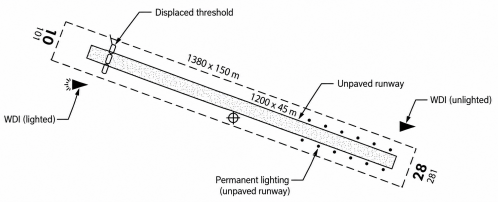
Volume 4 Aerodrome Plate
The top of an aerodrome plate provides important information about the aerodrome.